Diluvian Damage
Topic: Weather
Posted: Sun, Jan 16, 2005 ![]()
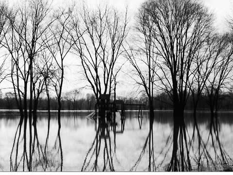
Following up on Steph Mineart's post, I had the opportunity to survey the flood damage on the North side yesterday (1/15). From my personal, non-scientific observations, it looks like this flood is worse than the Labor Day flood of 2003. So much for a 100-year flood; how about a 2-year flood?
Here's the view from just south of the 116th street bridge near the White River.
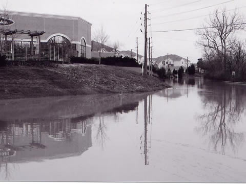
The following photo was taken at Keystone at the Crossing near the Borders strip mall.
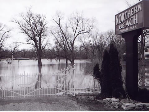
The next shot was taken at "Northern Beach" which is just south of 116th, and West of the White River. I've seen this area flood out several times before, but this is the highest I've personally seen it.
The NOAA chart of the White River's height shows that the peak was sometime on the 14th at 18.39 feet (the flood stage is 11 feet). (Note: this chart is updated frequently.) The USGS also maintains an Indiana Flood Page.
According to the NOAA, the top five White River flood events at Nora are as follows:
(1) 22.40 ft on 03/26/
(2) 19.19 ft on 01/01/1991
(3) 17.78 ft on 07/11/2003
(4) 16.85 ft on 01/07/2005
(5) 16.69 ft on 01/24/1999
The most recent flood stage of 18.39 feet will rank third on this list.
4 of the top 5 flood events have taken place within the last 15 years? It's easy to get alarmed about such things, but one must consider that the culprit could be global warming.
TrackBacks
TrackBack URL for this entry:
http://www.indyscribe.com/cgi-bin/mt-tb.cgi/71
Categories
- About Us
- Board and Video Games
- Books
- Day Trips
- Events & Festivals
- Film & TV
- Geek Bling
- History
- Hoosier Oddities
- Indianapolis In the News
- Indianapolis Living
- Kids' Stuff
- Local Attractions
- Local Celebrities
- Museums and Visual Arts
- Music
- Night Life
- Photos
- Restaurants
- Shopping
- Sports
- Theater
- Transportation
- Weather

Archives
IndyScribe Authors
- Jennifer Bortel
- Brad Koch
- Brent Mundy
Comments
1. Jan 16, 05 06:06 PM | Steph Mineart said:
I suspect the recent Tsunami is having some effect on our weather, also; it was a pretty big natual event to not cause some sort of odd weather patterns as a result...
2. Jan 17, 05 12:50 PM | Brent Mundy said:
The cold snap right after the last round of rain really helped keep the floods from getting much worse. By freezing the water in the ground, much of the run-off was prevented from flowing into the already overflowing rivers and streams in the area.
3. Jan 18, 05 08:26 AM | Rachel Wolfe said:
I don't know that the tsunami could have an effect on our weather, as it was an underwater event (the earthquake) and not an atmospheric one. In fact, I'm not sure I'd classify the tsunami as a "weather" event any more than I'd classify a dry-land earthquake as such. But all this rain has made my lake rise well above normal; people's dock gangways are under water, with the docks floating above...it will take a while for this to go down. On the bright side, June should be a great month for kayaking, this year!
4. Jan 18, 05 08:33 AM | Steph Mineart said:
The earthquake wouldn't affect our weather, but wouldn't the resulting tidal waves have some affect on the tides and atmosphere, and thus the weather? Of course, I'm not a weatherman, I'm just speculating. Perhaps I should do some googling on this...
5. Jan 20, 05 10:03 AM | Norm Stephens said:
Most weather patterns are related to the heating of ocean waters and their realtionship to air, and ocean currents. Most of our moisture comes from the Gulf of Mexico and the jet stream directs where the moisture ends up falling.
The hundred year flood doesn't really mean there will be a flood every hundred years ... it means the odds of a flood of that level occuring are 1 in a 100 ... in any given year. Too bad we can't get lotto odds that good.
6. Sep 15, 05 02:56 PM | Brent said:
If you are using OS X 10.4 there is a cool new Dashboard Widget that shows you realtime river flow information from the USGS:
Whitewater Widget
http://www.apple.com/downloads/dashboard/information/whitewaterwidget.html